The Circle Line (orange, code CC) loops around the city centre from Dhoby Ghaut to HarbourFront, with a short branch to Bayfront and Marina Bay. It lets you travel between the radial lines without riding all the way into downtown.
By connecting the other lines at their edges — Bishan, Serangoon, Paya Lebar, Buona Vista, one-north and HarbourFront — the Circle Line often saves a trip through the crowded city core, which makes it a favourite for cross-town journeys.
All Circle Line stations
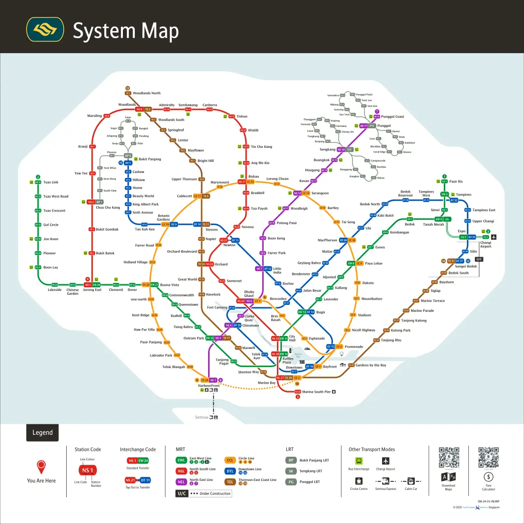
The Circle Line runs from Dhoby Ghaut to HarbourFront, plus a short branch. Coloured chips show where you can change to another MRT line.
- CC1Dhoby GhautNE6NS24
- CC2Bras Basah
- CC3Esplanade
- CC4PromenadeDT15
- CC5Nicoll Highway
- CC6Stadium
- CC7Mountbatten
- CC8Dakota
- CC9Paya LebarEW8
- CC10MacPhersonDT26
- CC11Tai Seng
- CC12Bartley
- CC13SerangoonNE12
- CC14Lorong Chuan
- CC15BishanNS17
- CC16Marymount
- CC17CaldecottTE9
- CC19Botanic GardensDT9
- CC20Farrer Road
- CC21Holland Village
- CC22Buona VistaEW21
- CC23one-north
- CC24Kent Ridge
- CC25Haw Par Villa
- CC26Pasir Panjang
- CC27Labrador Park
- CC28Telok Blangah
- CC29HarbourFrontNE1
- CE1BayfrontBranchDT16
- CE2Marina BayBranchNS27TE20
Circle Line on the system map
See how the Circle Line connects to the rest of the network.
Plan a route on the Circle Line
MrtGo plans the full journey across the Circle Line and every connecting line, showing which station to change at and the fare for your trip. See also our guide to using the Singapore MRT, first and last train times, and MRT fares.
Attractions on the Circle Line
- Marina Bay Sands (Bayfront)
- Universal Studios Singapore (HarbourFront)
- Sentosa Island (HarbourFront)
- Singapore Flyer (Promenade)
- Singapore Botanic Gardens (Botanic Gardens)
- Esplanade (Esplanade)
- Haw Par Villa (Haw Par Villa)